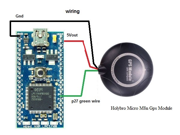
GPS UAV, Latitude,Longitude, Speed, Heading, GPS Fix, No.Of Sats. HDOP


Revision 1:ae1120188730, committed 2019-02-24
- Comitter:
- Rbinas
- Date:
- Sun Feb 24 02:01:36 2019 +0000
- Parent:
- 0:8508616aa661
- Commit message:
- Rev 0
Changed in this revision
| GPSUAV.h | Show annotated file Show diff for this revision Revisions of this file |
| main.cpp | Show annotated file Show diff for this revision Revisions of this file |
--- /dev/null	Thu Jan 01 00:00:00 1970 +0000
+++ b/GPSUAV.h	Sun Feb 24 02:01:36 2019 +0000
@@ -0,0 +1,160 @@
+#ifndef GPSUAV_H_
+#define GPSUAV_H_
+
+#include "mbed.h"
+
+#ifdef __cplusplus
+extern "C" {
+#endif
+
+Serial gps(p28, p27);  // TX, RX GPS
+Serial pc(USBTX, USBRX);// TX, RX
+char s[85];
+char y1,y2,y3,y4,y5,y6,y7,y8,y9;
+char x1,x2,x3,x4,x5,x6,x7,x8,x9,x10;
+char NS,WE;
+char GPSBuffer[85];
+char Latitude[10];
+char Longitude[11];
+
+char spd1,spd2,spd3,spd4,spd5,spd6,spd7;
+char speed[8];
+float speedInt;
+
+char hdg1,hdg2,hdg3,hdg4,hdg5;
+char HDG[5];
+char Heading[6];
+float HeadingInt;
+
+char GpsFix[2];
+char GF;
+int GFInt;
+char NOS[3];
+char Nos1,Nos2;
+int NOSInt;
+char HDOP[6];
+char Hdp1,Hdp2,Hdp3,Hdp4,Hdp5;
+float HDOPInt;
+
+char LatDeg[3];
+char LatMin[8];
+int LatDegInt;
+float LatMinInt;
+
+char LongDeg[4];
+char LongMin[8];
+int LongDegInt;
+float LongMinInt;
+void wait_ms(int us);
+
+void EnableGPS()
+{
+        pc.baud(9600);
+        GPSBuffer[0] = '\0';
+        while (1) {
+            char c = gps.getc();
+            s[0] = c;
+            s[1] = '\0';
+            strcat(GPSBuffer, s);
+            if (c == '\n') {
+                break;
+            }
+  if ((GPSBuffer[1] == 'G') && (GPSBuffer[2] == 'N') && (GPSBuffer[3] == 'R') && (GPSBuffer[4] == 'M') && (GPSBuffer[5] == 'C')&& (GPSBuffer[17] == 'A'))
+  { // $GNRMC,174216.00,A,3908.86289,N,07647.84392,W,2.419,237.21,210219,,,A*6E
+
+    //Latitude---------------------------------------------------------------------------------------------------------------
+    y1= GPSBuffer[19]; y2 = GPSBuffer[20]; //Degrees
+    y3= GPSBuffer[21]; y4 = GPSBuffer[22];y5= GPSBuffer[24]; y6 = GPSBuffer[25];y7= GPSBuffer[26]; y8 = GPSBuffer[27];y9= GPSBuffer[28]; //DEGMIN
+    NS = GPSBuffer[30];
+
+    sprintf(LatDeg,"%c%c",y1,y2);
+    sprintf(LatMin,"%c%c%c%c%c%c%c",y3,y4,y5,y6,y7,y8,y9);
+
+    LatDegInt = atoi(LatDeg);
+    LatMinInt = atoi(LatMin);
+    LatMinInt = LatMinInt/100000;
+  //----------------------------------------------------------------
+    //Longitude
+    x1= GPSBuffer[32]; x2= GPSBuffer[33]; x3= GPSBuffer[34];//Degrees
+    x4=GPSBuffer[35]; x5=GPSBuffer[36]; x6=GPSBuffer[38]; x7=GPSBuffer[39]; x8=GPSBuffer[40]; x9=GPSBuffer[41];x10=GPSBuffer[42];//DEGMIN
+    WE=GPSBuffer[44];
+
+    sprintf(LongDeg,"%c%c%c",x1,x2,x3);
+    sprintf(LongMin,"%c%c%c%c%c%c%c",x4,x5,x6,x7,x8,x9,x10);
+
+    LongDegInt = atoi(LongDeg);
+    LongMinInt = atoi(LongMin);
+    LongMinInt = LongMinInt/100000;
+
+ //--------------------------------------------get speed------------------------------------------------------------------
+  if((GPSBuffer[47] == '.')&& (GPSBuffer[51] == ','))//2.419
+   {
+    spd1=GPSBuffer[46]; spd2=GPSBuffer[47]; spd3=GPSBuffer[48]; spd4=GPSBuffer[49]; spd5=GPSBuffer[50];
+    sprintf(speed,"00%c%c%c%c%c",spd1,spd2,spd3,spd4,spd5);
+   }
+  if((GPSBuffer[48] == '.')&& (GPSBuffer[52] == ','))//24.191
+   {
+    spd1=GPSBuffer[46]; spd2=GPSBuffer[47]; spd3=GPSBuffer[48]; spd4=GPSBuffer[49]; spd5=GPSBuffer[50]; spd6=GPSBuffer[51];
+    sprintf(speed,"0%c%c%c%c%c%c",spd1,spd2,spd3,spd4,spd5,spd6);
+   }
+  if((GPSBuffer[49] == '.')&& (GPSBuffer[53] == ','))//240.191
+   {
+    spd1=GPSBuffer[46]; spd2=GPSBuffer[47]; spd3=GPSBuffer[48]; spd4=GPSBuffer[49]; spd5=GPSBuffer[50]; spd6=GPSBuffer[51]; spd7=GPSBuffer[52];
+    sprintf(speed,"%c%c%c%c%c%c%c",spd1,spd2,spd3,spd4,spd5,spd6,spd7);
+   }
+    speedInt = atof(speed); //speed in knots
+
+//----------------------------------------get Heading-------------------------------------------------------------------
+ }
+ if ((GPSBuffer[1] == 'G') && (GPSBuffer[2] == 'N') && (GPSBuffer[3] == 'V')&& (GPSBuffer[4] == 'T')&& (GPSBuffer[5] == 'G'))//MC Sentence
+{
+
+   if((GPSBuffer[8] == '.')&& (GPSBuffer[10] == ','))//2.4
+   {
+    hdg1=GPSBuffer[7]; hdg2=GPSBuffer[8]; hdg3=GPSBuffer[9];
+    sprintf(Heading,"00%c%c%c",hdg1,hdg2,hdg3);
+   }
+    if((GPSBuffer[9] == '.')&& (GPSBuffer[11] == ','))//20.4
+   {
+    hdg1=GPSBuffer[7]; hdg2=GPSBuffer[8]; hdg3=GPSBuffer[9]; hdg4=GPSBuffer[10];
+    sprintf(Heading,"0%c%c%c%c",hdg1,hdg2,hdg3,hdg4);
+   }
+   if((GPSBuffer[10] == '.')&&(GPSBuffer[12] == ','))//200.4
+   {
+    hdg1=GPSBuffer[7]; hdg2=GPSBuffer[8]; hdg3=GPSBuffer[9]; hdg4=GPSBuffer[10]; hdg5=GPSBuffer[11];
+    sprintf(Heading,"%c%c%c%c%c",hdg1,hdg2,hdg3,hdg4,hdg5);
+   }
+    HeadingInt=atof(Heading);
+}
+if ((GPSBuffer[1] == 'G') && (GPSBuffer[2] == 'N') && (GPSBuffer[3] == 'G')&& (GPSBuffer[4] == 'G')&& (GPSBuffer[5] == 'A'))//MC Sentence
+{  //$GNGGA,193247.00,3908.85437,N,07647.82746,W,1,11,0.86,50.0,M,-34.7,M,,*4E start at 44
+
+     GF=GPSBuffer[44];
+     sprintf(GpsFix,"%c",GF);
+     GFInt = atoi(GpsFix);//gpsfix
+
+     Nos1=GPSBuffer[46];
+     Nos2=GPSBuffer[47];
+     sprintf(NOS,"%c%c",Nos1,Nos2);//number of sats
+     NOSInt = atoi(NOS);
+
+    if((GPSBuffer[50] == '.')&& (GPSBuffer[53] == ','))//0.66
+   {
+      Hdp1=GPSBuffer[49]; Hdp2=GPSBuffer[50]; Hdp3=GPSBuffer[51]; Hdp4=GPSBuffer[52];
+      sprintf(HDOP,"0%c%c%c%c", Hdp1,Hdp2,Hdp3,Hdp4);
+   }
+    if((GPSBuffer[51] == '.')&& (GPSBuffer[54] == ','))//00.66
+   {
+      Hdp1=GPSBuffer[49]; Hdp2=GPSBuffer[50]; Hdp3=GPSBuffer[51]; Hdp4=GPSBuffer[52];Hdp5=GPSBuffer[53];
+      sprintf(HDOP,"%c%c%c%c%c",Hdp1,Hdp2,Hdp3,Hdp4,Hdp5);
+   }
+     HDOPInt = atof(HDOP);//hdop
+}
+}
+}
+
+#ifdef __cplusplus
+}
+#endif
+
+#endif // #ifndef GPSUAV_H_
\ No newline at end of file
--- a/main.cpp	Wed May 02 03:53:27 2018 +0000
+++ b/main.cpp	Sun Feb 24 02:01:36 2019 +0000
@@ -1,50 +1,25 @@
 #include "mbed.h"
+#include "GPSUAV.h"
 //Board:mbed LPC1768
-//Veriy GPS Lat/Long buffer Data from GNRMC sentence.If using Nema 0183 GPS, Change GNRMC to GPRMC
-//GPS Receiver: HolyBro
-//Wait until you get a good fix
-Serial gps(p9, p10);       // TX, RX
-Serial pc(USBTX, USBRX);    // TX, RX
 DigitalOut led1(LED1);
+//Altitude not included, deemed unreliable for UAV appliations. Use Pitot tube or AGL.

-char s[82];
-char y1,y2,y3,y4,y5,y6,y7,y8,y9;
-char x1,x2,x3,x4,x5,x6,x7,x8,x9,x10;
-char NS,WE;
-char GPSBuffer[1024];
-
+//---------------------------------------------------------------
 int main() {
-    pc.baud(9600);
-
-   // char gpsout[1024];
+
     while (1) {
-        GPSBuffer[0] = '\0';
-        while (1) {
-            char c = gps.getc();
-           // char s[2];
-            s[0] = c;
-            s[1] = '\0';
-            strcat(GPSBuffer, s);
-            if (c == '\n') {
-                break;
-            }
-
-if ((GPSBuffer[1] == 'G') && (GPSBuffer[2] == 'N') && (GPSBuffer[3] == 'R') && (GPSBuffer[4] == 'M') && (GPSBuffer[5] == 'C'))//GNRMC Sentence
-  {
-    //Latitude
-    y1= GPSBuffer[19]; y2 = GPSBuffer[20]; //Degrees
-    y3= GPSBuffer[21]; y4 = GPSBuffer[22];y5= GPSBuffer[24]; y6 = GPSBuffer[25];y7= GPSBuffer[26]; y8 = GPSBuffer[27];y9= GPSBuffer[28]; //DEGMIN
-    NS = GPSBuffer[30];
-    //Longitude
-    x1= GPSBuffer[32]; x2= GPSBuffer[33]; x3= GPSBuffer[34];//Degrees
-    x4=GPSBuffer[35]; x5=GPSBuffer[36]; x6=GPSBuffer[38]; x7=GPSBuffer[39]; x8=GPSBuffer[40]; x9=GPSBuffer[41];x10=GPSBuffer[42];//DEGMIN
-    WE=GPSBuffer[44];
+
+    EnableGPS();
+     pc.printf("%02d ",LatDegInt); pc.printf("%08.5f",LatMinInt);pc.printf("%c ",NS);//latitude
+      pc.printf("%03d ",LongDegInt);pc.printf("%08.5f",LongMinInt);pc.printf("%c",WE);//longitude
+      pc.printf(" %07.3f",speedInt);//speed
+      pc.printf(" %05.1f",HeadingInt);//heading
+      pc.printf(" %1d",GFInt);//gpsfix
+      pc.printf(" %02d",NOSInt);//number of sats
+      pc.printf(" %05.2f\n",HDOPInt);//hdop
+
+      led1 = !led1;
+
   }
-        }
-
-     pc.printf("Latitude:%c%c:%c%c.%c%c%c%c%c %c",y1,y2,y3,y4,y5,y6,y7,y8,y9,NS); //Print latitude buffer data
-     pc.printf(" Longitude:%c%c%c:%c%c.%c%c%c%c%c %c\r\n",x1,x2,x3,x4,x5,x6,x7,x8,x9,x10,WE); //Print Longitude buffer data

-    led1 = !led1;
-    }
 }