GPS U-blox NEO-6M
Introduction
You can found this module on ebay a very low price.
Product Specifications
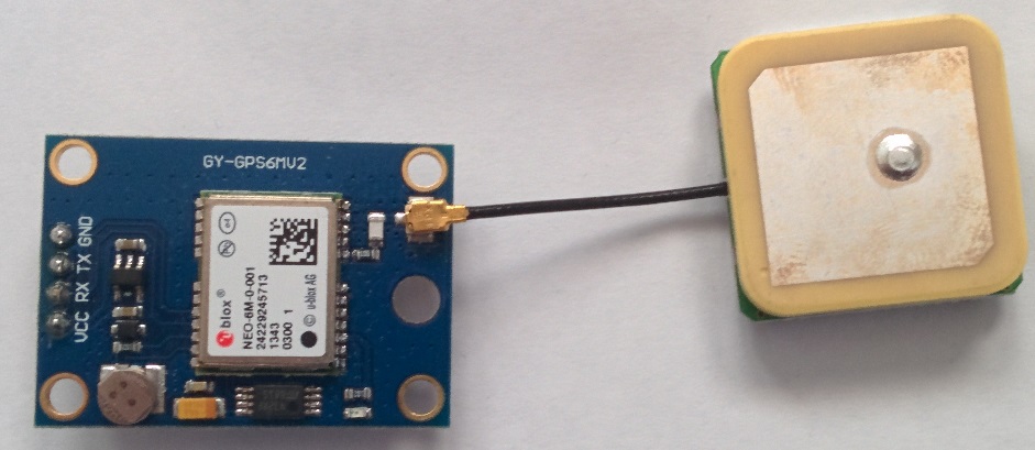
Board: GY-GPS6MV2
GPS Module: NEO-6M-0-001 (datasheet)
Antenna Socket:IPEX
Output Protocol : NMEA
Pin Description
| GPS pin | MBED pin | Bambino 210E pin |
|---|---|---|
| VCC | Vout | 3.3V |
| RX | P13 | UART0_TX |
| TX | P14 | UART0_RX |
| GND | GND | GND |
NMEA Protocol
- GPGGA (Global positioning system fix data)
| Field | Name | Format | Unit | Description |
|---|---|---|---|---|
| 0 | $GPGGA | string | - | Message ID, GGA protocol header |
| 1 | hhmmss.ss | hhmmss.sss | - | UTC Time |
| 2 | Latitude | ddmm.mmmm | - | Latitude |
| 3 | N | char | - | N/S Indicator |
| 4 | Longitude | dddmm.mmmm | - | Longitude |
| 5 | E | char | - | E/W indicator |
| 6 | FS | digit | - | Position Fix Status Indicator |
| 7 | NoSV | numeric | - | Satellites Used |
| 8 | HDOP | numeric | - | Horizontal Dilution of Precision |
| 9 | msl | numeric | m | MSL Altitude |
| 10 | uMsl | char | - | Units, Meters |
| 11 | Altref | numeric | m | Geoid Separation |
| 12 | uSep | char | - | Units, Meters |
| 13 | DiffAge | numeric | s | Age of Differential Corrections |
| 14 | DiffStation | numeric | - | Diff. Reference Station ID |
| 15 | cs | hexadecimal | - | Checksum |
| 16 | <CR><LF> | char | - | Carriage Return and Line Feed |
- GPGSA (GNSS DOP and Active Satellites)
| Field | Name | Format | Unit | Description |
|---|---|---|---|---|
| 0 | $GPGSA | string | - | Message ID, GSA protocol header |
| 1 | Smode | char | - | Manual or Automatic (for 2D or 3D mode) |
| 2 | FS | digit | - | Fix status |
| ... | ||||
| 18 | cs | hexadecimal | - | Checksum |
| 19 | <CR><LF> | char | - | Carriage Return and Line Feed |
- GPGLL (Latitude and longitude, with time of position fix and status)
| Field | Name | Format | Unit | Description |
|---|---|---|---|---|
| 0 | $GPGLL | string | - | Message ID, GLL protocol header |
| 1 | Latitude | ddmm.mmmm | - | Latitude |
| 2 | N | char | - | N/S Indicator |
| 3 | Longitude | dddmm.mmmm | - | Longitude |
| 4 | E | char | - | E/W indicator |
| 5 | hhmmss.ss | hhmmss.sss | - | UTC Time |
| 6 | Valid | char | - | V = Data invalid, A = Data valid |
| 7 | cs | hexadecimal | - | Checksum |
| 8 | <CR><LF> | char | - | Carriage Return and Line Feed |
- GPRMC (Recommended Minimum data)
| Field | Name | Format | Unit | Description |
|---|---|---|---|---|
| 0 | $GPRMC | string | - | Message ID, RMC protocol header |
| 1 | hhmmss.ss | hhmmss.sss | - | UTC Time |
| 2 | Status | char | - | V = Navigation receiver warning, A = Data valid |
| 3 | Latitude | ddmm.mmmm | - | Latitude |
| 4 | N | char | - | N/S Indicator |
| 5 | Longitude | dddmm.mmmm | - | Longitude |
| 6 | E | char | - | E/W indicator |
| 7 | Spd | numeric | knots | Speed over ground |
| 8 | Cog | numeric | degrees | Course over ground |
| 9 | date | ddmmyy | - | Date in day, month, year format |
| 10 | mv | numeric | degrees | Magnetic variation value |
| 11 | mvE | char | - | Magnetic variation E/W indicator |
| 12 | mode | char | - | Mode Indicator |
| 13 | cs | hexadecimal | - | Checksum |
| 14 | <CR><LF> | char | - | Carriage Return and Line Feed |
Test Code
Import programGPS_U-blox_NEO-6M_Test_Code
Test code for GPS U-blox NEO-6M
Output
You need to wait the GPS fix.

C# Program
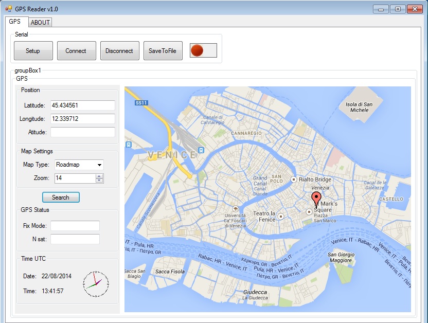
You can download the program here: GPS Reader v1.0
Is required Microsoft .NET Framework 4.5 or above.
This program works also without gps device. Simply enter the latitude and longitude and then press "Search".

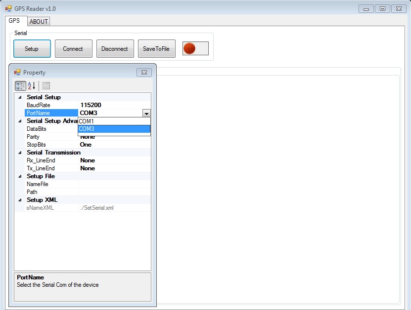
With the gps device you must first press the button "Setup" and set the Port Com and the baud rate.

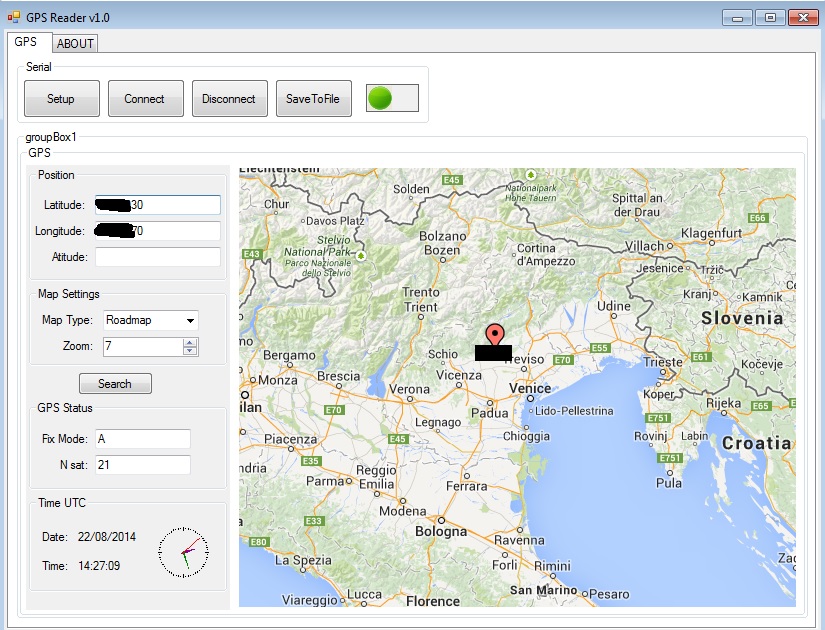
In the end when the gps makes the fix you press "Search" for see the place.

1 comment on GPS U-blox NEO-6M:
Please log in to post comments.


Hi i'm working in a drone and i want to know, how can i modify your code in order to use this module as the drone gps, and set the home point and if it lost the control signal it'll be able to return